OpenET released daily and monthly data on evapotranspiration (ET) for the eastern half of the U.S. at a spatial scale of one-quarter of an acre per pixel. The data are freely available through OpenET’s easy-to-use Data Explorer, Application Programming Interface (API), and mobile-friendly Farm and Ranch Management Support (FARMS) tool.
The release represents an expansion of OpenET to 25 more states. The platform originally launched in 2021 with data in 17 western states and expanded to 23 states in 2023. Today, OpenET has more than 13,000 registered users who routinely retrieve data for a wide variety of applications, ranging from irrigation scheduling for individual fields to water accounting across major U.S. river basins. OpenET also launched a redesigned website (https://etdata.org/) and logo to coincide with the U.S. expansion.
“The expansion of OpenET is a major milestone for making critical water data even more widely accessible for landowners and water managers across the U.S.,” said Sara Larsen, CEO of OpenET. “While OpenET launched with a focus on western arid regions confronting major drought, we know these data will be valuable to landowners and water managers across the country who want to better understand patterns in ET. For instance, resource managers can use OpenET to track water trends over time across large regions to evaluate the effectiveness of different forest and rangeland management plans.”
“It’s all about finding new ways to make satellite data easier to access and use for as many people as possible,” said Forrest Melton, the OpenET project scientist at NASA’s Ames Research Center in Silicon Valley. “The goal is to empower users with actionable, science-based data to support decisions about water management.”
“Before OpenET, getting water use data was challenging and cost prohibitive for the majority of farming and ranching operations,” said Maurice Hall, senior advisor, climate resilient water systems, at Environmental Defense Fund. “Thanks to a unique public-private-philanthropic partnership, OpenET makes critical water data widely accessible for all landowners across the United States, serving as an invaluable tool to help accelerate testing and adoption of more sustainable and innovative water management practices.”
“As a partner from day one, Google is thrilled to see OpenET expanding their ET data to all 48 contiguous U.S. states,” said Karin Tuxen-Bettman, Google Earth Engine program manager. “OpenET is a powerful example of how Google Earth Engine and technology can support the sustainable management of our planet’s critical natural resources, in this case water. Water is fundamental to the health of our planet and people, so we are celebrating this significant step by OpenET and look forward to ensuring this data gets into the hands of people who need it most to sustainably manage our water resources.”
“The USGS Water Availability and Use Science program uses satellite-derived evapotranspiration data to estimate irrigation water use for the nation to fulfill a portion of its mission to improve the nation’s understanding of water availability,” said Jaime Painter, USGS Water Use Science program manager.
Filling a critical gap in water management
OpenET fills a major information gap in water management. While water is essential to our food supply, communities, and economies, getting access to accurate, timely ET data has been fragmented and often expensive, keeping it out of the hands of many farmers and decision-makers. OpenET allows users to easily view and download this important water data for current and recent years (since 2016) for free.
The latest expansion of OpenET to the East Coast makes this important water dataset available at high resolution (30 meters x 30 meters or 0.22 acres per pixel) but does not yet include any field boundary data. Field-level water data are expected to be available for the eastern half of the country in early 2026.
In addition to providing water data in the U.S., OpenET is being expanded to provide data for Brazil to better understand drying trends and the impact of land use changes on the Amazon River Basin.
“OpenET provides real-time insights into crop water use that farmers have never had before,” said Dwane Roth, a semiretired fourth-generation Kansas farmer and advocate of producer-led innovation. “When combined with soil-moisture probes, OpenET helps producers grow more with less water — a game-changer for the next generation of agriculture.”
“I am excited to have OpenET covering most of the United States because it has huge potential to improve the management of plantations in the southeast and forest management in many areas of the U.S.,” said Yun Yang, an OpenET board member and assistant professor at Cornell University’s School of Integrative Plant Science.
Yang has used ET data for research on a North Carolina Loblolly pine plantation and natural forests in Missouri and New Jersey. “Having data from OpenET at my fingertips instead of needing to run calculations on my own, as I have done in the past, will significantly accelerate my research on the relationship between evapotranspiration and forest and plantation thinning as well as drought-induced tree mortality,” Yang added.
Applications of OpenET
Since its launch in 2021, OpenET has been used in a wide variety of ways, from the farm to the multistate scale. Current applications include:
- Irrigation management: From an individual landowner to large companies including Gallo and Sun Pacific Farming, OpenET helps growers of all sizes estimate crop water demand to optimize irrigation, maintain or improve yields, and reduce costs. OpenET data can be integrated into platforms that include soil moisture, nutrient data, and other inputs to guide irrigation scheduling. By providing cost-effective and often more accurate ET information, OpenET enhances the performance and affordability of these decision-support tools. For example, it’s been estimated that incorporating field-scale OpenET data into irrigation scheduling just for California almond orchards could generate $127.5 million in savings and total economic value for water users over a five-year period. California grape growers also report up to 25% water savings by integrating OpenET tools into their irrigation management practices.
- Groundwater accounting and management: Water agencies in California and Nebraska are using OpenET in an open-source groundwater accounting platform, developed by EDF and partners, to help farmers track and manage their water budgets, while agencies in Oregon and Kansas are in the process of developing pilot projects with the accounting platform.
- Water use reporting: The California Central Delta Water Agency and South Delta Water Agency use OpenET as an alternative means to support water use reporting to the state, which has led to an increase in landowner reporting and significant cost savings for farmers in the Delta.
- Consistent data for river basin management: The U.S. Bureau of Reclamation, four states of the Upper Colorado River Basin (CO, UT, NM, and WY), and the Upper Colorado River Commission officially adopted one of the OpenET models to serve as the basis for irrigated agricultural consumptive use measurement across the upper basin.
- Conservation programs: OpenET supports the development, implementation, and monitoring of agricultural water conservation programs to reduce consumptive use in water-stressed regions.
What is ET?
The “ET” in OpenET stands for evapotranspiration — the process in which water evaporates from the land surface and transpires, or is released, from plants. ET is a key measure of water consumed by crops and other vegetation that can be used by farmers and water managers to better track water use as well as water saved, for instance, when farmers change crops or invest in new technologies.
The “Open” in OpenET refers to the commitment of the nonprofit, OpenET science team, and broader consortium of public- and private-sector partners to providing open access to these data with no cost to view, download, or use it within standard usage limits. OpenET combines satellite information with local weather data to accurately calculate ET using six independent models and an ensemble ET value, which have been developed over several decades by leading scientists. OpenET runs on Google Earth Engine, which provides a shared geospatial computing platform that allows the OpenET science team and software engineers to efficiently collaborate to produce open, high accuracy, reproducible and scientifically-based data for the U.S.
ET can be computed by satellites because the ET process absorbs energy and cools the land surface, and vegetation reflects and absorbs different amounts of visible and near-infrared light depending upon the density and health of the vegetation. These effects are visible to thermal and optical sensors on satellites like Landsat, as well as the ECOSTRESS instrument onboard the International Space Station.
OpenET data have been extensively compared to ground-based measurements collected in agricultural fields and natural landscapes, and tested by a wide variety of organizations through several use cases to ensure the highest accuracy.
Additional Resources:
Media contact: Ronna Kelly, [email protected]
Media Kit: Click here.
Stories from the field: https://etdata.org/openet-for-growers/
YouTube: https://www.youtube.com/@openetdata4047
LinkedIn: https://www.linkedin.com/company/openetdata/
###
About OpenET
A public-private collaboration led by NASA, USGS, California State University Monterey Bay, Environmental Defense Fund, Desert Research Institute, Google Earth Engine and HabitatSeven, OpenET uses publicly available data produced by NASA, USGS Landsat, and other satellite and ground-based systems to calculate evapotranspiration rates at the field level. OpenET is supported through federal, state, and philanthropic funding to ensure the dataset remains accurate, reliable, and publicly accessible.
DENVER (AP) — NASA on Thursday launched an online platform with information on how much water evaporates into the atmosphere from plants, soils and other surfaces in the U.S. West, data it says could help water managers, farmers and state officials better manage resources in the parched region.
]]>Media Contact: Jonathan Seefeldt, EDF, (512) 691-3414, [email protected]
Experienced Water Resources Leader to Spearhead Expanding Nonprofit Water Data Platform
(Las Vegas, NV – Nov 18, 2024) OpenET, a non-profit initiative dedicated to providing easily accessible satellite-based data for improved water management, is pleased to announce the appointment of Sara Larsen as its new Chief Executive Officer. Larsen brings more than two decades of experience in water resources management, data sharing, and cross-jurisdictional collaboration to her new role, where she will lead OpenET’s efforts to both refine and expand access to critical, field-level water data.
Larsen has been at the forefront of collaborative water data innovation for more than a decade. She comes to OpenET from dual leadership roles at the Lincoln Institute of Land Policy and the Internet of Water, a data modernization initiative through which Larsen has worked with a broad coalition to address technology and capacity barriers to water data sharing.
Larsen is steeped in both the core issues and key partnership pathways to addressing water management pressures in the American West and beyond. From 2019 to 2024, she served as Deputy Director and Chief Engineer for the Upper Colorado River Commission, where she managed multidisciplinary teams on crucial Colorado River Basin initiatives, including modeling, consumptive use estimation, water conservation program implementation, data infrastructure development, and more.
She has been an early champion and advocate for the OpenET platform, as it presents a science-based, cutting-edge, and transparent approach to measuring critical water data. Her tenure at the Commission led to the four Upper Colorado River Basin states’ adoption of one of OpenET’s methods for the purpose of interstate water management. Her dedication to collaboration and innovation was instrumental in advancing the Commission’s goals of promoting partnerships, interstate cooperation, and the sustainable management of the Colorado River’s critical resources. Prior to the Commission, Larsen worked with the Western States Water Council to drive open water data-sharing initiatives across 17 states.
Larsen’s decade-long leadership in water data is built on an extensive foundation in civil engineering and water resource management. After early roles with the State of Utah and the Provo River Water Users Association, she earned a Master’s degree in Civil Engineering and Water Resources from the University of Utah. She subsequently worked with Los Alamos National Laboratory as an infrastructure modeler, where she gained a deep understanding of advanced modeling techniques.
Reflecting on her new role, Larsen shared, “Accessible, accurate data is transforming water management at every scale. From its inception a decade ago, OpenET has driven this shift by making the most critical and elusive piece of water management — accurate evapotranspiration data — available and actionable for all. I am thrilled to lead OpenET in advancing this mission and look forward to strengthening the partnerships that make this platform such a vital tool for a sustainable future.”
“OpenET’s commitment to accessible, science-driven water data is transforming the way we approach water challenges. Sara’s leadership comes at the perfect time — her deep expertise and passion for effective, collaborative water data will further sharpen OpenET’s efforts to advance the availability and usability of water data in support of a sustainable future,” said Joya Banerjee, OpenET board of directors chair and head of U.S. programs, Waverley Street Foundation.
“OpenET is embarking on a bold endeavor to build a benchmark for water resource management across the globe. Blazing this trail will require passion, determination, and vision. I believe Sara can help the team deliver more accurate, timely, and useful water data to the world, and I am excited to watch and help them succeed,” said Brett Baker, OpenET board member, California Delta farmer, and water attorney.
]]>By Katie Klug, Brandon Ertis, Jeff Davids, and Will Carrara
In the Colusa Subbasin, which spans more than 700,000 acres in California’s Sacramento Valley, data obtained through the OpenET application programming interface (API) and data services are being used to help meet the challenge of monitoring water use across a diverse landscape with varying water sources and demands. As beta testers of the OpenET API, Davids Engineering has benefitted from the data services the API provides, especially its utility for easily and efficiently retrieving large quantities of ET data for custom areas and time frames, with greater capabilities for automation and time efficiency. This is particularly important as the Subbasin’s two groundwater sustainability agencies – the Colusa Groundwater Authority (CGA) and the Glenn Groundwater Authority (GGA) – work with a diverse group of stakeholders to manage the complex groundwater conditions in the Colusa Subbasin under California’s Sustainable Groundwater Management Act (SGMA).
The OpenET API has provided Davids Engineering, the CGA, and GGA a consistent and efficient way to calculate consumptive water use and crop water demand in the Colusa Subbasin during SGMA implementation. To help capture changing conditions over time, Davids Engineering has leveraged spatial ET data from OpenET together with other spatial land use and surface water supply information. These data are used to compute crop water demand and, in turn, model the amount of groundwater pumping needed to meet demand in areas without sufficient surface water supplies. This information is critical for developing water budgets and for evaluating the impacts of hydrologic conditions and groundwater management practices on consumptive water use.
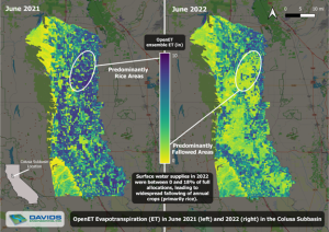
Most recently, Davids Engineering supported the CGA and GGA in evaluating consumptive water use from different sources in the Colusa Subbasin during water years 2021-2022 as part of their Groundwater Sustainability Plan Annual Reports. OpenET was especially valuable for evaluating crop water demand in this two-year period because conditions were vastly different each year. While both years were dry from a hydrologic perspective, water year 2022 saw substantial curtailments of surface water supplies available for irrigation in many parts of California. In the Colusa Subbasin, these cutbacks led to widespread changes in crop cultivation practices, including substantial idling of rice crops. The impacts that idling had on crop water demand were seen directly in the OpenET data (Figure 1). OpenET allowed Davids Engineering to capture the full extent and impact of idling on crop water use in 2022 with greater accuracy than might have otherwise been captured using traditional crop coefficient approaches or other data sources with more limited spatial or temporal resolution.
Overall, OpenET has provided many benefits in ongoing efforts to support sustainable groundwater management in the Colusa Subbasin and elsewhere in California. Davids Engineering plans to continue using OpenET information to evaluate and track changes in water use, develop water budgets, and investigate the impacts of groundwater management practices over the next 20 years. Groundwater sustainability agencies in California, like the CGA and GGA, are leading the way in sustainable groundwater management, and the use of innovative tools like OpenET will help them to achieve their goals.
Figure 1. Map of ET in the Colusa Subbasin in 2021 and 2022 showing the impacts of reduced surface water supplies in 2022. Decreases in ET are observed for the annotated region where land use changed from predominantly rice in 2021 to predominantly fallow in 2022.
“We at Davids Engineering have been really impressed with the OpenET API. The endpoints are well-designed, and the Swagger user interface for testing is intuitive. The documentation is comprehensive, including useful code examples. The support team has also been responsive and super helpful.”
Jeff Davids, Davids Engineering
]]>California is responsible for 12.5% of all agricultural production in the United States, as well as one third of the country’s vegetables and three quarters of its nut and fruit production. This agricultural activity is reliant on a hugely dynamic and complex plumbing system that stores and transports water across the state. And yet, extended droughts over the past two decades have highlighted the need for accurate water measurement and reporting. These data can be used by the state to plan ahead and forecast for times of water scarcity, identify and correct water losses in a diversion system, administer and protect water rights, and efficiently manage water during times of shortage.
In 2015, the California legislature passed Senate Bill 88, which requires water rights holders and claimants who divert over 10 acre-feet per year to accurately report water diversions to the California State Water Resources Control Board (CA SWRCB). The Delta Alternative Compliance Plan (Delta ACP), which has been under development for the past three years, provides a path to comply with the measurement regulation and simplifies and streamlines annual reporting.
This requirement poses a particular challenge in the important farming region of the Sacramento-San Joaquin Delta, where 70 different crops are grown across over 415,000 acres, creating nearly 14,000 jobs and $2 billion in output. Most of the agricultural land in the Delta is below sea level and in tidally influenced zones behind protective levees, requiring complex water delivery and management infrastructure. Siphons are used to move water from surrounding channels to agricultural fields. However, these channels can also cause flooding when too much water seeps out onto the fields. Measuring flow through the Delta’s numerous siphons is particularly challenging due to hydraulic turbulence, tidal fluctuation, and ingested debris. Traditional compliance approaches require using flow meters to measure all points of diversion, which in the Delta’s complex hydrologic environment can be especially expensive to install and maintain, and often do not provide the required accuracy
Recognizing this challenge, the Delta water community—including regulators, farmers, exporters, environmental non-profits and water districts—came together in 2020 to develop an approach supported by water users that would fulfill the state’s reporting requirement.
The Delta Alternative Compliance Plan (Delta ACP) launched on March 16, 2023 by the Central and South Delta Water Agencies. The Delta ACP addresses two problems: improvement of an otherwise complicated and expensive water measurement system and automation of an onerous reporting system. This innovative plan allows farmers to use satellite-based information on evapotranspiration (ET) from OpenET to automatically quantify and report water use to the CA SWRCB, streamlining the water use reporting process in the hydrologically complex San Francisco Bay-Delta region.
Delta Watermaster, Jay Ziegler, is hopeful about the Delta ACP’s ability to both improve the water measurement process in the legally-defined Delta, as well as contribute to the long-term goal of building resiliency through the application of a user-friendly and cost effective water data reporting platform that fosters engagement across all stakeholders to better understand water use data.
“The Delta ACP program is an important step in applying technology to better answer the longstanding difficult water measurement challenges in the Sacramento-San Joaquin Delta,” says Ziegler. “The use of OpenET is a significant and practical improvement in collecting, applying and understanding consumptive water use data in the watershed. Advancing wider understanding about consumptive water use is essential to then engage all stakeholders toward a better understanding of hydrodynamics of the Delta”
With the Delta ACP system, farmers and water rights holders can automatically retrieve water use data for their farms from the OpenET application programming interface (API) and open data services, which is combined with information automatically retrieved from the CA SWRCB Report Management System API. This represents the first time that satellite data are being used to report water use in California, and the first time that the CA SWRCB water use reporting APIs and open data services from OpenET have been integrated.
The Delta ACP helps farmers and water rights holders report total water use as required under California Water Code Sections 5104 and 1840. With the Delta ACP, the reporting process is streamlined and automated, allowing farmers to complete water use reports in under 10 minutes. This represents a significant improvement over the past reporting systems, where farmers had to hire consultants or spend up to 8 hours to complete the reports for each of the thousands of farms in the Delta region.
Lindsay Kammeier, Water Resource Control Engineer for CA SWRCB and the Office of the Delta Watermaster, sees multiple benefits to implementation of the Delta ACP. “It is a reliable and accurate way for diverters, wider Delta water interests and the regulator to understand consumptive water use in the watershed. It improves data collection and reporting for both users and the SWRCB’s analysis and establishes a common baseline to measure consumptive water use,” says Kammeier. “Open ET provides an accurate calculation of that value for in-Delta agricultural users and closer real-time access to measure water use data. That data is consistent, reliable and credible within the user community.”
Brett Baker, sixth-generation pear farmer and legal counsel for the Central Delta Water Agency, has been assisting his community with water reporting for well over a decade. He is excited about the opportunity the Delta ACP and OpenET provide in terms of empowering Delta water users to comply on their own.
“Following the passage of the Delta Reform Act in 2009, which required diverters within the Legal Delta to annually report their diversion and use of water for the first time, I endeavored to assist my family, friends, and neighbors in fulfilling this new regulatory requirement. I built a business, became an attorney, and started a family. All the while, I hoped to be able to empower Delta water users with the ability to comply with the regulations on their own. OpenET has given us the opportunity to do exactly that,” Brett says. “The Delta Alternative Compliance Program that we built allows Delta Farmers to continue doing what they do best, which is farm, and allows them to be in full compliance with the law utilizing OpenET’s technology in an easily accessible, affordable, and understandable Application.”
A common understanding of water usage and needs is critical for sustainable water management. This innovative application of OpenET represents one of many potential ways satellite-based data can be mobilized for a whole water community-including growers, water managers and regulators- to better report and effectively manage water usage in a complex system. Perhaps more impressively, water regulators, managers and users agreed on what data to use and how to report the data, ultimately saving money, simplifying the burden of regulatory compliance, and building a foundation for a collaborative future on water measurement in the Delta.
]]>
“Given recent years of low hydrology, climate change, and increased pressures on water users across the Basin, we don’t have the luxury of not utilizing the best available science and data for consumptive water use information.” — Sara Larsen, Deputy Director and Chief Engineer, Upper Colorado River Commission
This past summer, as the Colorado River Basin entered another historically dry year, the Upper Division States of Utah, Colorado, Wyoming, and New Mexico, through the Upper Colorado River Commission (UCRC), took an important step forward for sustainable water management by adopting a new method for measuring and reporting consumptive water use for interstate purposes.
After a nine-year study, the UCRC commissioners unanimously adopted a satellite-based method called eeMETRIC as the standard for measuring evapotranspiration (ET) and agricultural consumptive water use. This method is one of six methods (plus an ensemble) available to farmers, water managers, and interested stakeholders on the OpenET platform.
Evapotranspiration is a measure of the amount of water consumed by crops and other plants as they grow and can often be used to derive consumptive water use, which refers to all of the water within a system that cannot be recovered or reused. Accurate, timely, and reliable ET data can provide water managers with new approaches and opportunities to better measure water consumption and balance water supply and demand.
The Upper Colorado River Basin Compact, signed in 1948, created the UCRC and directs it to measure consumptive water use in the Upper Basin to ensure that obligations in the 1922 Colorado River Compact to the Lower Basin are met. Aside from that pivotal role, accurate and timely measurement of consumptive water use is important because the data support critical river operations modeling and long-term planning for the Colorado River, which provides water to 40 million people, irrigates more than five million acres of land, and flows through 11 national parks.
How using different methods made interstate water management challenging
Previously, the Upper Division States, UCRC, and the Bureau of Reclamation used different methods to estimate water use that produced incompatible results, making it challenging for water managers and decision-makers to effectively use the data at interstate scales.
In an effort to improve data accuracy and consistency and enable more collaborative and responsive decision-making across state lines, the Upper Division States and Reclamation funded the effort to review and analyze a range of potential methods that showed some promise given the Upper Basin’s challenging topography and other characteristics.
The Consumptive Use Study Workgroup included representatives of the Upper Division States, the UCRC, and a multitude of academic researchers and contractors. The nine-year investigation included 1) an in-depth review of the various methods in use by the States at the outset; 2) an assessment of the expansion of climate and meteorological information needed to enable the consideration of more updated methods; and 3) a detailed, ground-truthed trial of crop coefficient and remote-sensing methods.
Why eeMETRIC was selected
Based on considerations regarding accuracy, consistency with the best available science, relative cost, and ability to produce timely information, the study authors recommended the use of eeMETRIC as implemented within the OpenET framework, to measure agricultural water use in the Upper Basin. On June 14, the UCRC commissioners unanimously adopted a resolution to use eeMETRIC to measure agricultural consumptive use in the Upper Basin.
Sara Larsen, the UCRC’s deputy director and chief engineer, said that the resolution is a significant milestone in the Upper Basin’s efforts to quantify water use. She envisions a host of potential applications for timely and accurate agricultural consumptive use measurement, including the potential for better quantifying water conservation in the Upper Basin. The OpenET platform makes access to such data more accessible and transparent, serving as an efficient and easy-to-use tool for landowners who wish to better understand or quantify water use and track water savings over time.
In tandem with the Upper Basin, Reclamation has also transitioned to the use of eeMETRIC for calculating agricultural consumptive water use estimation related to irrigated lands for its annual Consumptive Uses and Losses Reports. The development of eeMETRIC (which stands for Google Earth Engine implementation of the Mapping Evapotranspiration at high Resolution with Internalized Calibration model) was led by Dr. Richard Allen of the University of Idaho and Dr. Ayse Kilic of the University of Nebraska-Lincoln.
The OpenET team became a critical partner to the Upper Basin Consumptive Use Study in its final year. OpenET provided a comprehensive intercomparison of method performance using the study data that demonstrated how satellite-based ET data could be produced and delivered in a timely, transparent, and inexpensive manner. The workgroup recommended that, as the science of consumptive use estimation continues to evolve and improve, the Upper Division States and UCRC continue to monitor those improvements and stay current with consumptive use estimation science and measurement. The OpenET platform will be a critical partner in that effort.
]]>“OpenET is at the forefront of a new technology that can provide an efficient, cost-effective, and timely way to measure consumptive water use on multiple scales, from the field to the basin. We look forward to continuing our work with Reclamation and the OpenET team to investigate ways to further develop this tool and to continue to advance the state of the science in the Colorado River Basin.” — Sara Larsen, Deputy Director and Chief Engineer, Upper Colorado River Commission
“The changing climate is dramatically increasing wildfire risks across the West, which also threatens our already shrinking water supplies. OpenET is giving Salt River Project a unique opportunity to learn more about how forest thinning projects that reduce wildfire risk also improve watershed health in the short and long term.”
—Elvy Barton, Forest Health Management Principal, Salt River Project
Bureau of Reclamation
“Every five years, the Bureau of Reclamation reports on water use and loss for the Upper Colorado River Basin states. As Colorado River flows significantly decline, the Bureau’s five-year report will be more important than ever. OpenET will serve as a valuable tool to help the Bureau to compare several satellite-based methods for measuring water consumption and determine which approach is most appropriate for the five-year Colorado River report.”
—James Prairie, Hydrologic Engineer, U.S. Department of Interior, Bureau of Reclamation
California
“California’s last drought demonstrated that reliable water data is almost as critical to farmers and water managers as the water supply itself. As our state and the entire western U.S. grapple with even more severe drought as a result of climate change, the launch of OpenET comes at a pivotal moment. It offers farmers and water managers a collaborative, 21st century tool to plan for and adapt to rapidly shifting water needs.”
—E. Joaquin Esquivel, Chair, California State Water Resources Control Board
“OpenET represents a game-changing leap forward for water management in the West. Starting in January 2022, OpenET will give Delta farmers a much easier, less expensive way to comply with state rules on monitoring and reporting water use. Instead of physically measuring every diversion, Delta farmers will be able to submit OpenET’s estimate of their crop water use. OpenET will save time, money, and confusion in the Delta, the hub of California’s water supply.”
—Michael George, Delta Watermaster
“Measuring water use in the Delta with traditional ground-based tools is a fool’s errand because of the region’s unique hydrology. OpenET provides us the ability to gain a more precise, timely and meaningful measurement of water use in the Delta. OpenET will be of great value for Delta farmers, state regulators, and policymakers as we collaborate to better manage our common vital water resources for our future.”
—Brett Baker, Sixth-generation Pear Farmer and Attorney, Central Delta Water Agency
“Gallo has invested substantially in ET data research because it enables us to use water much more sustainably as we face more frequent heat spikes and increasingly severe droughts. Working with USDA and NASA, we have experimentally used ET data to adjust irrigation amounts to actual vine water needs and to reduce applied water by up to 20%. But we need OpenET to be able to scale this application to all our vineyard acres.”
—Maria Mar Alsina, Research Scientist, E. & J. Gallo Winery
“To comply with California’s Sustainable Groundwater Management Act, Rosedale turned to OpenET for highly accurate water data to help our landowners more easily manage their own groundwater budgets through an online accounting platform. Because OpenET has brought together so many leading experts on satellite-based water data, I’m confident OpenET will become the de facto source of water data across not only California but the entire West.”
—Eric Averett, Board Member, California Water Data Consortium, and CEO, Homer LLC; Former General Manager, Rosedale-Rio Bravo Water Storage District
Colorado
“OpenET is a major step forward for managing water needs in a time when the Colorado River Basin is facing unprecedented challenges. New tools to help our farmers and ranchers more effectively manage their water use not only supports their crop and bottom line, but creates opportunities for more water to remain in our river systems to benefit both people and nature.”
—Aaron Derwingson, Water Projects Director, Colorado River Program, The Nature Conservancy
Nevada
“The Nevada Division of Water Resources strongly supports the continued development and public accessibility of OpenET. This outstanding tool directly benefits water users throughout Nevada and the West who strive to improve efficiency and conserve water. Public access to these data will be increasingly vital to support water users and responsible water management needs into the future.”
—Adam Sullivan, Nevada State Engineer, Nevada Division of Water Resources
“If you give farmers better information on when they should and shouldn’t have their water on, you’re going to save water. I think that’s the great value of OpenET.”
—Denise Moyle, Nevada Alfalfa Farmer
Oregon
“As the basin where I farm runs a substantial groundwater deficit, I have used ET data to design more efficient irrigation systems that reduce applied water by up to 25% and electricity costs by up to 20%. Because ET data is so important, I introduced legislation to use OpenET to develop water budgets for every groundwater basin in Oregon to ensure we have enough water for a growing population as droughts become more extreme. If you haven’t experienced climate change yet, it’s coming, and we need data and technology like OpenET to help us adapt.”
—Mark Owens, Oregon State Representative and Alfalfa Farmer
Utah
“The development of OpenET is fundamental to filling a data black hole related to consumptive use of water. We are thrilled with the prospects it provides for improved, informed water management at the scale of basin and farm, alike.”
—Bart Leeflang, Colorado River Program Manager, Central Utah Water Conservancy District
Washington
“The old adage is that you can’t manage what you don’t measure. For water managers, water users and citizens alike, understanding how much water is being consumed at both the farm and watershed level is an immense challenge. The OpenET platform will simplify that task and will do it in a way that is cost-effective, scientifically sound, transparent and accessible. OpenET will inform our work at both the operational and planning levels. It’s an especially welcomed tool as climate change shapes our understanding of future water availability.”
—Mary Verner, Water Resources Program Manager, Washington State Department of Ecology
Western States Water Council
“Currently, access to satellite and ET data is limited and expensive to process and interpret for many water users and decision-makers. OpenET will provide credible, transparent, automated, easily accessible consumptive water use data, through a broad network of collaborators also developing and refining operational applications. No other system can provide easier access to more timely data with more refined spatial coverage.”
—Tony Willdardson, Executive Director, Western States Water Council
Media Contact: Jonathan Seefeldt, EDF, (512) 691-3414, [email protected]
OpenET makes satellite-based data widely accessible to help 17 states develop more resilient water supplies
(SACRAMENTO, CA — October 21, 2021) OpenET, a new online platform that uses satellites to estimate water consumed by crops and other plants, launched today, making critical data for water management widely available in 17 western states for the first time amid record drought.

OpenET fills a major information gap in water management in the West. Although water is essential to the health of our communities, wildlife, and food supply, access to accurate, timely data on the amount of water used to grow food has been fragmented and often expensive, keeping it out of the hands of many farmers and decision-makers. OpenET allows users to easily view and download this important water data for the current year and previous five years at no charge.
OpenET is providing this data down to the field scale in 17 western states as water supplies become increasingly scarce due to drought, climate change and population growth. The states covered by OpenET are Arizona, California, Colorado, Idaho, Kansas, Montana, Nebraska, Nevada, New Mexico, North Dakota, Oklahoma, Oregon, South Dakota, Texas, Utah, Washington, and Wyoming.
“OpenET addresses one of the biggest data gaps in water management in the western United States,” said Forrest Melton, program scientist for the NASA Western Water Applications Office. “This easy-to-use online platform provides scientifically robust data that are invaluable for water management at all scales, from an individual agricultural field to an entire river basin.”
“As water supplies become increasingly scarce in arid regions, we need new, innovative tools like OpenET to manage water more precisely and sustainably,” said Robyn Grimm, director, climate resilient water systems, at Environmental Defense Fund (EDF). “OpenET provides all farmers, policymakers and communities big and small with the same high-quality data on water use, so that we can all work together from the same playbook to develop more resilient water supplies across the West.”
“OpenET is a powerful application of cloud computing that will make a measurable impact on the ground in the agriculture sector. Google is proud to support such an important new tool to help improve water sustainability in the western United States as we see the impacts of climate change intensify,” said Google Earth Engine developer advocate Tyler Erickson.
“OpenET combines decades of research with advances in technology from just the past five years to make valuable water data much more affordable and accessible to all,” said Justin Huntington, a research professor at Desert Research Institute. “In the future we hope to expand OpenET to other arid regions of the world, such as South America, India and Africa.”
“As someone who has worked on evapotranspiration for more than 40 years, I am thrilled to see multiple, independent models for estimating ET come together on a single, easy-to-navigate platform,” said Richard Allen, a professor of water resources engineering at the University of Idaho. “By putting these water consumption data into the hands of farmers and water managers across the western United States, OpenET will be transformative in helping us manage water more sustainably,” added Ayse Kilic, a professor at the University of Nebraska-Lincoln.
“In some parts of the arid West, more than 70% of irrigation water ends up as evapotranspiration. By automating calculations for this highly important water data, OpenET will enable the USGS and water managers to more easily create water budgets at the watershed scale, which is an essential first step toward proactive water management,” said Gabriel Senay, a research scientist with the U.S. Geological Survey.
“Irrigated agriculture is essential to feeding a growing population,” said Martha Anderson, a research scientist with the U.S. Department of Agriculture. “OpenET will be a powerful tool to help our nation’s farmers increase food production under conditions of limited freshwater resources.”
“OpenET has not just transformed access to information on ET, but has also facilitated important advances in the underlying science,” said Josh Fisher, a research scientist with the University of California, Los Angeles. “The collaborative approach used to develop OpenET will accelerate our ability to scale the platform to other regions, and to rapidly incorporate new information from future satellite missions.”
“The development of multi-model tools based on cloud computing, as provided by OpenET, is a paradigm shift, allowing water resources management in sustainable ways, not only in the United States, but also in many agricultural regions of the world, where agriculture and irrigation are increasing rapidly, as in Brazil”, added Anderson Ruhoff, a professor at the Universidade Federal do Rio Grande do Sul in Brazil.
Applications of OpenET data include:
- Informing irrigation management and scheduling to maximize “crop per drop” and reduce costs for water, fertilizer and energy. ET data are being used by E&J Gallo Winery in California and Oregon state legislator and alfalfa farmer Mark Owens to reduce applied irrigation water while sustaining crop yields and quality.
- Enabling water and land managers to develop more accurate water budgets, water trading programs and other innovative programs. Rosedale-Rio Bravo Water Storage District in California’s San Joaquin Valley is using OpenET in its online accounting and trading platform. Salt River Project in Arizona is using OpenET to improve their understanding of the impacts of wildfire and forest management on streamflow and groundwater recharge.
What is evapotranspiration?
The “ET” in OpenET stands for evapotranspiration — the process by which water evaporates from the land surface and transpires, or is released, from plants. ET is a key measure of water consumed by crops and other vegetation that can be used by farmers and water managers to better track water use as well as water saved, for instance, when farmers change crops or invest in new technologies.
Evapotranspiration can be estimated by satellites because the ET process absorbs energy and cools the land surface, and vegetation reflects and absorbs different amounts of visible and near-infrared light depending upon the density and health of the vegetation. These effects are visible to thermal and optical sensors on a satellite. Using sophisticated biophysical models, OpenET combines satellite information with local weather data to accurately estimate ET.
Using publicly available data, OpenET brings together six independent models for estimating evapotranspiration onto a single computing platform, ultimately helping to build broader trust and agreement around this information.
OpenET data has been extensively compared to ground-based measurements collected in agricultural fields and natural landscapes, and tested by a wide variety of organizations through several use cases to ensure the highest accuracy.
Unprecedented public-private partnership
OpenET has been developed through an unprecedented public-private collaboration with input from more than 100 farmers, water managers, and other stakeholders. The project is led by Environmental Defense Fund, NASA, Desert Research Institute, and HabitatSeven. Additional team members include Google, U.S. Geological Survey, U.S. Department of Agriculture, California State University Monterey Bay, University of Idaho, University of Maryland, University of Nebraska-Lincoln, University of Wisconsin-Madison, UCLA, and Universidade Federal do Rio Grande do Sul in Brazil.
The OpenET project has received funding from the NASA Applied Sciences Program Western Water Applications Office, S. D. Bechtel, Jr. Foundation, Gordon and Betty Moore Foundation, Walton Family Foundation, The Keith Campbell Foundation for the Environment, Lyda Hill Philanthropies, The Laney and Pasha Thornton Foundation, Water Funder Initiative, Desert Research Institute Maki Endowment, Delta Water Agencies, and the Windward Fund.
Providing farmers and local water managers free ET data is a core objective of the OpenET project. For-profit entities and other organizations looking for large-scale access to OpenET data will be able to purchase it through an application programming interface (API) expected to launch in 2022. Revenue generated will fund continuing research and development of OpenET data services.
Additional Resources:
Environmental Defense Fund (edf.org), a leading international nonprofit organization, creates transformational solutions to the most serious environmental problems. EDF links science, economics, law and innovative private-sector partnerships. Connect with us on Twitter, Facebook and our Growing Returns blog.
The National Aeronautics and Space Administration (nasa.gov) is a U.S. government agency that leads an innovative program of exploration with commercial and international partners to enable human expansion across the solar system and bring new knowledge and opportunities back to Earth. With its fleet of Earth-observing satellites and instruments, NASA uses the vantage point of space to understand and explore our home planet, improve lives and safeguard our future.
The Desert Research Institute (dri.edu) is a recognized world leader in basic and applied environmental research. Committed to scientific excellence and integrity, DRI faculty, students who work alongside them, and staff have developed scientific knowledge and innovative technologies in research projects around the globe. Since 1959, DRI’s research has advanced scientific knowledge on topics ranging from humans’ impact on the environment to the environment’s impact on humans. DRI’s impactful science and inspiring solutions support Nevada’s diverse economy, provide science-based educational opportunities, and inform policymakers, business leaders, and community members. With campuses in Las Vegas and Reno, DRI serves as the non-profit research arm of the Nevada System of Higher Education.
Google Earth Engine (earthengine.google.com) is a geospatial processing platform that combines a multi-petabyte catalog of satellite imagery and other geospatial datasets with planetary-scale analysis capabilities. The platform is enabling scientists, developers and decision-makers to make substantive progress on global environmental and sustainability challenges.
]]>Media Contact: Jonathan Seefeldt, EDF, (512) 691-3414, [email protected]
OpenET will provide easily accessible satellite-based water data to help build a resilient future for agriculture.
(SACRAMENTO, CA — Sept. 15, 2020) Environmental Defense Fund (EDF), NASA, the Desert Research Institute (DRI) and Google announced plans today to develop a new web application called OpenET to enable western U.S. farmers and water managers to accurately track water consumption by crops and other vegetation using data from satellites and weather stations.
A virtual media briefing and demo of OpenET will be held at 11 a.m. Pacific time today. To join, visit https://edf.zoom.us/j/94778845937 or call 669-900-9128 or 346-248-7799 and enter the meeting code: 94778845937#.
OpenET will fill a critical information gap in water management in the West. Today, access to accurate, timely satellite-based data on the amount of water used to grow food is fragmented and often expensive, keeping it out of the hands of many farmers and decision-makers. Water supplies in the western U.S. are critical to the health of our communities, food supply and wildlife, but they are facing increasing pressures in the face of population growth and a changing climate.
Applications of OpenET data include:
- Informing irrigation management and scheduling practices to maximize “crop per drop” and reduce costs for water and fertilizer.
- Enabling water and land managers to develop more accurate water budgets and innovative management programs that promote adequate water supplies for agriculture, people and ecosystems.
Supporting groundwater management, water trading and conservation programs that increase the economic viability of agriculture across the West.

What is evapotranspiration?
The “ET” in OpenET stands for evapotranspiration — the process by which water evaporates from the land surface and transpires from plants. Evapotranspiration, a key measure of water consumed by crops and vegetation, can be tracked by satellites because the process cools plants and soil down, so irrigated fields appear cooler in satellite images.
Using publicly available data, OpenET will make several methods for estimating evapotranspiration more widely accessible, ultimately helping to build broader trust and agreement around this information. OpenET will also make it possible to track the amount of evapotranspiration reduced when farmers change cropping patterns, invest in new technologies or adopt water-saving practices.
OpenET is expected to be available to the public in 2021.
OpenET will initially provide field-scale ET data in 17 states, with plans to expand to the entire United States and beyond. The 17 states are Arizona, California, Colorado, Idaho, Kansas, Montana, Nebraska, Nevada, New Mexico, North Dakota, Oklahoma, Oregon, South Dakota, Texas, Utah, Washington and Wyoming.
“OpenET will help fill one of the biggest data gaps in water management in the western United States. Our primary goal is to make sure we are providing evapotranspiration data that is accurate, consistent, scientifically based and useful for water management, whether for an individual agricultural field or an entire river basin,” said Forrest Melton, program scientist for the NASA Western Water Applications Office. “OpenET is being created through an innovative collaboration among a national team of scientists, technology experts, farmers, government policy-makers and environmental nonprofits.”
“OpenET is a powerful application of cloud computing that will lead to measurable results on the ground in the agriculture sector. Google is proud to support such an important new tool,” said Google Earth Engine developer advocate Tyler Erickson.
“After 10 years of working with farmers and water agencies to develop ET estimates, it couldn’t be more rewarding to be creating an application like OpenET that uses best available science and makes ET data much more affordable and accessible to all,” said Justin Huntington, a research professor at Desert Research Institute. “We also see OpenET having the potential to scale up to other regions of the world, including South America and Africa.”
“OpenET will empower farmers and water managers across the West to build more accurate water budgets and identify stress, resulting in a more resilient system for agriculture, people and ecosystems,” said Robyn Grimm, senior manager, water information systems, at EDF. “We envision OpenET leveling the playing field by providing all farmers with data that until now have not been widely accessible to everyone.”
Unprecedented collaboration
OpenET is being developed with input from more than 100 stakeholders across the West.
NASA, EDF, DRI and HabitatSeven are the project leads for OpenET. Additional collaborators include Google Earth Engine, USGS, USDA Agricultural Research Service, California State University Monterey Bay, University of Idaho, University of Maryland, University of Nebraska-Lincoln and University of Wisconsin-Madison.
The OpenET project has received funding from the NASA Applied Sciences Program Western Water Applications Office, S. D. Bechtel, Jr. Foundation, Gordon and Betty Moore Foundation, Walton Family Foundation, Water Funder Initiative, Lyda Hill Philanthropies, Delta Water Agencies, and the Windward Fund. In-kind support has been provided by Google Earth Engine and partners in the agricultural and water management communities.
Providing farmers and local water managers free ET data is a core objective of the OpenET project. For-profit entities and other organizations looking for large-scale access to OpenET data will be able to purchase it through an application programming interface (API). Revenue generated will fund continuing research and development of OpenET data services.
Support for OpenET
“The Harney Basin is running a groundwater deficit of 120,000 acre-feet to 130,000 acre-feet per year. We have used ET data to gain a better understanding of our water consumption and design more efficient irrigation systems that use about 15% less water. This could translate to a savings of 18% to 20% on electricity costs for pumping, too. With the demands on water from a growing population and feeding more people, we have to figure out how to get the best value from every drop of water. ET data is crucial to providing this information. ”
—Oregon State Rep. Mark Owens. Owens owns or manages 3,200 acres of farmland.
“Reliable water data is almost as critical to farmers and water managers as the water supply itself. With added pressure from population growth and the uncertainty that climate change impacts have on existing and future water supply, OpenET allows planning for agricultural water needs in a way that just wasn’t possible before.”
—E. Joaquin Esquivel, Chair of the California State Water Resources Control Board
“Every five years, the Bureau of Reclamation is tasked with creating a report that summarizes water use and loss for the Upper Colorado River Basin states. Currently, there are several satellite-based methodologies to measure water, many of which will be incorporated into OpenET. Consequently, OpenET will serve as a valuable tool for us to test and compare ET measurement methodologies to determine the best approach for future studies.”
—James Prairie, Hydrologic Engineer, U.S. Department of Interior, Bureau of Reclamation
“OpenET will be a valuable tool to estimate historical and current water consumed by crops across Nevada. OpenET data also will be especially useful for monitoring consumptive use to support local groundwater management plans that are needed in response to long-term groundwater level declines.”
—Adam Sullivan, P.E., Nevada Deputy State Engineer
“To comply with the new groundwater law in California, it’s imperative to have accurate, transparent water use data to serve to build a groundwater budget. But currently ET data can be very expensive to acquire from consultants or universities, and the methodologies are often inconsistent and unclear. Consequently, Rosedale turned to OpenET for accurate parcel-level ET water data at a lower cost to build an online accounting platform for our landowners to more easily manage their own groundwater budgets. Because the OpenET project has brought together a team of leading experts on several approaches for measuring ET, I’m confident it will become the de facto source of water data among landowners and water managers alike.”
—Eric Averett, General Manager, Rosedale-Rio Bravo Water Storage District (California)
“OpenET represents a game-changing leap forward for water management in the West. OpenET will give water users in the Delta a much less expensive alternative method for complying with the state requirement to monitor and report on their water diversions. Instead of physically measuring every diversion in the Delta, farmers will be able to look up OpenET’s estimate of their crop water use. If the estimate is acceptable to the farmer, the farmer knows that it will be acceptable to us. Concurring on OpenET’s ensemble measurement will save time, money and confusion.”
—Michael George, Delta Watermaster (California)
“OpenET is a great step forward for managing water needs in a time when demand far surpasses supply. Helping our farmers and ranchers more effectively manage their water use not only helps their crop and bottom line, but creates opportunities for more water to remain in our river systems to benefit both people and nature.”
—Aaron Derwingson, Water Projects Director, Colorado River Program, The Nature Conservancy
Additional Resources:
Environmental Defense Fund (edf.org), a leading international nonprofit organization, creates transformational solutions to the most serious environmental problems. EDF links science, economics, law and innovative private-sector partnerships. Connect with us on Twitter, Facebook and our Growing Returns blog.
The National Aeronautics and Space Administration (nasa.gov) is a U.S. government agency that leads an innovative program of exploration with commercial and international partners to enable human expansion across the solar system and bring new knowledge and opportunities back to Earth. With its fleet of Earth-observing satellites and instruments, NASA uses the vantage point of space to understand and explore our home planet, improve lives and safeguard our future.
The Desert Research Institute (dri.edu) is a recognized world leader in basic and applied interdisciplinary research. Committed to scientific excellence and integrity, DRI faculty, students, and staff have developed scientific knowledge and innovative technologies in research projects around the globe. Since 1959, DRI’s research has advanced scientific knowledge, supported Nevada’s diversifying economy, provided science-based educational opportunities, and informed policymakers, business leaders, and community members. With campuses in Reno and Las Vegas, DRI is one of eight institutions in the Nevada System of Higher Education.
Google Earth Engine (earthengine.google.com) is a geospatial processing platform that combines a multi-petabyte catalog of satellite imagery and other geospatial datasets with planetary-scale analysis capabilities. The platform is enabling scientists, developers and decision-makers to make substantive progress on global environmental and sustainability challenges.
]]>