
To our Plex Pilot iOS Users
Our Plex Pilot iOS app will no longer be available for download on the app store following June 14, 2024.
DJI has recently announced the end of their support for iOS MSDK. As Plex Pilot iOS depends on the iOS MSDK, we will not be able to maintain the functionality and quality of Plex Pilot iOS.
Moving forward, we highly recommend using Plex Pilot Android if you’re flying your DJI drones. Download from the Google Play Store.
Plex Pilot Android still supports DJI MDSK v4, which you can use with your older DJI drones. Note that this will also follow the DJI deprecation schedule.
A new version that supports DJI MSDK v5 drones is coming soon.
We apologize for any inconvenience this may have caused your drone operations and thank you for your continued support. If you would like to use control software that doesn’t go out of fashion so soon, check out our Cerana UAS, which is flown using Plex Pilot for Cerana.
The post Plex Pilot for iOS discontinued appeared first on Garuda Robotics.
]]>The post Spirit of Enterprise Awards 2022 appeared first on Garuda Robotics.
]]>
On 28 Nov 2022, Mark and Jiin Joo joined 44 other companies to be recognised with the Spirit of Enterprise (SOE) Award 2022. The SOE Award is a distinguish honour that’s presented only to companies whose entrepreneurial excellence encourages innovation, fair practices, and growth in entrepreneurship.
SOE organises the SOE Awards annually to honour and recognise Singapore business entrepreneurs’ achievements. Award honourees are evaluated and selected from the pool of SOE nominees interviewed by student interviewers, and are exemplary role models who have contributed towards the economic development of Singapore.
We want to take this opportunity to dedicate this award especially to
- Our investors who have believed in our mission and journey towards creating the platform for autonomous air mobility
- Our past and present staff who gave in their best to keep our customers happy and build the future of drone technology
- Our customers who went along the innovation journey to bring our mutual vision of connected and intelligent air vehicles to life
It’s always Day 1 – onward to greater heights!
Read more:
- Minister of State Low Yen Ling’s speech at the SOE Award ceremony
- SOE website and facebook page
The post Spirit of Enterprise Awards 2022 appeared first on Garuda Robotics.
]]>The post Garuda Robotics and OneSky Partner to Provide UTM Services in Malaysia appeared first on Garuda Robotics.
]]>Garuda Robotics (GR), in an exclusive partnership with OneSky, aims to provide Unmanned Aircraft Traffic Management (UTM) services to aviation authorities, city governments, enterprises and security agencies in Malaysia. Garuda Robotics’ operations at Drone & Robotics Zone (DRZ) Iskandar Drone Test Site (DTS) in Iskandar Puteri aims to be a showcase for the value this collaboration can unlock for Malaysia.
The DRZ Iskandar DTS, comprising two separate parcels of land dedicated to drone operations, will be available for all users for conducting training; UA R&D and testing; and validating advanced operations.
All DRZ Iskandar DTS airspace operations will be coordinated at GR’s on-site Drone Operations Centre in Iskandar Puteri (DOC@IP).

Wei Cong Lim, Software Engineer, Garuda Robotics; Jiin Joo Ong, CTO, Garuda Robotics, Mark Yong, CEO, Garuda Robotics.
The DOC@IP is equipped with the latest technologies and physical infrastructure, including:
- Plex Horizon, for Command and Control (C2) of Beyond Visual Line of Sight (BVLOS) operations
- OneSky Unmanned Aircraft Traffic Management System (UTMS), for tactical deconfliction and conformance monitoring
- MyDroneFleets Network Remote ID (NetRID), for drone-agnostic airspace management
- Operational support such as Coworking space, workshop, charging station, storage, etc.
Consultancy and services for all site users will be provided by Garuda Robotics, with the primary goal of empowering Malaysian enterprises to effectively scale their drone operations. These services include:
- Assistance with permit applications and government liaison
- Logistics (through our partnership with DHL)
- Fleet management
- Systems consultancy
- Human capital and talent development
- Liaison with international partners
The list of services can be found on mydronefleets.com/drz-iskandar-dts
Managing Director of Garuda Robotics (Malaysia) Sdn Bhd, Mr. Frederick Ooi, says: “The DRZ Iskandar DTS will be an ideal govt-approved segregated airspace to facilitate verification of the safety of UAS operations and related flight procedures, support govt authorities like CAAM, SIRIM, and MCMC during the development of certification standards, provide tech companies a proper space to conduct R&D of new drone solutions and drone flight training, and will be the go-to place for drone flying in southern Johor.”
For companies evaluating the site usage for BVLOS test, OneSky will provide risk assessments that are SORA and/or ASTM compliant as well as UTM services. In risk assessment, risk likelihood is determined using results from OneSky’s operational analytics. OneSky will be providing UTM services including:
- Registration
- UTM Core Services
- Airspace Management
- Flight Management
- Situational Awareness
- UTM Aeronautical Information Management
CEO of OneSky, Robert Hammett, remarked “We are excited to work with our partner Garuda Robotics at DRZ Iskandar DTS to provide the ASEAN drone industry with robust testing facilities to prove out technology that accelerates drone operations. This effort builds on our partnership with Garuda Robotics as we jointly deliver end-to-end solutions for the drone industry. We look forward to working with the DRZ Iskandar and its customers to further their efforts in expediting drone adoption.”
DRZ Iskandar is a catalytic initiative championed by Iskandar Investment Berhad (IIB). It is a strategic project aimed at building a vibrant drone and robotics technology ecosystem, increasing the 4IR technology adoption and a talent hub which serves as a growth engine for Malaysia.
DOC@IP is set to supercharge the DRZ Iskandar, benefiting both domestic Malaysian drone companies, and also Singapore drone companies due to its proximity to Singapore. Many activities considered too high-risk to be carried out in densely populated areas in Singapore can now be safely tested in the dedicated sites under DRZ Iskandar DTS, with facilities provided by GR and Group of Companies under IIB.
A UTM system is important to manage drone operations effectively and safely in a drone test site. With the partnership of GR and OneSky’s UTM, this may be deployed at DRZ Iskandar’s DTS to serve the drone industry and provide essential data to the regulators which may be the first of its kind in Malaysia.
About OneSky
OneSky is a global UTM company developing airspace assessment, operations, and traffic management solutions for the aviation industry. Our goal is to harmonize the sky – ensuring safe, efficient, and scalable access to all airspace users. We take a robust and long-term approach to UTM, envisioning the challenges ahead as traffic management is unified for all operators. By working with all stakeholders – drone operators, drone manufacturers, and airspace authorities – we understand the unique challenges of this ecosystem and serve the critical needs of the community. Learn more at https://onesky.xyz.
About Garuda Robotics
Garuda Robotics is a leading developer of industrial-grade drones, drone operations platforms, and drone data solutions for enterprise, government, and professional drone operators. We support the local drone industry with technology, consultancy, and opportunities, from routine drone applications to advanced cutting edge innovation and collaboration, and connect the industry with key stakeholders such as airspace authorities, physical spaces for testing and learning, and the ecosystem of innovators. Our vision is to be both the physical and technological platform for safe, smart, and secure drone testing and operations. Learn more at https://garuda.io
The post Garuda Robotics and OneSky Partner to Provide UTM Services in Malaysia appeared first on Garuda Robotics.
]]>See the area for MDE on Garuda Plex or MyDroneFleets.
For the application to use the MDE to run trials, you will need to provide MPA with the following details:
- Company Name
- UEN Number
- Name and contact details of applicant
- Description of business case and how do you intend to carry out the trial
- Trial Period required at the MDE (Trial dates must be within the approved flight permit)
- Provision of a Risk Management and Emergency Response Plan
- CAAS Drone Operator Permit
- CAAS Approved Activity permit
When ready, submit the application directly to MPA at [email protected].
MPA would usually take about 5 to 7 working days to assess your application. Upon approval, you will receive further details on how you can using the booking website to schedule your drone trials at MDE.
The post Drone Testing at Maritime Drone Estate appeared first on Garuda Robotics.
]]>
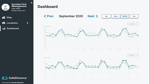
The Aerial Solution for Safe Management Measures
Real-Time Crowd Estimation from Above
Our solution is an integrated system that can capture, analyse and visualise crowd estimation in real-time.
How does SafeDistance work?
Capture
Video streaming is available for areas with good mobile network coverage.
Analyse
Our computer vision model is trained using drone images, which is more accurate than off the shelf AI.
Visualise
We will help you tally counts, keep history, and visualize the impact of your safe distancing measures.
Bring Your Own Drone
 Fly safely, legally and responsibly in accordance with the regulations in your local jurisdictions.
Safety without Compromising on Privacy

50% off SafeDistance for Garuda Plex Customers
We are no long offering complimentary SafeDistance trials.
However, for a limited time only, Garuda Plex Live Tier customers are entitled to a 50% discount off a SafeDistance subscription.
Click the Sign Up button below and we will get you started with a SafeDistance account.
Get Started with Real-Time Crowd Estimation
The post SafeDistance appeared first on Garuda Robotics.
]]>
Updates to Unmanned Aircraft Regulations
The Civil Aviation Authority of Singapore (CAAS) announced updates to the Unmanned Aircraft (UA) regulatory restrictions in October. The regulations now include basic training requirements in the form of a UA Basic Training Certificate (UABTC) or a UA Pilot License (UAPL). This is on top of the mandatory registration of UA weighing over 250g and obtaining the necessary operating permits for UA flying.
What this means for UA users
Recreational UA users should get a UAPL if their UA exceeds a total weight of 7kg. Education UA users that operate UA weighing more than 7kg will need to get a UAPL, an Operator Permit, and a Class 1 Activity Permit regardless of the location and height at which the UA is flown.
Commercial UA users must get a UAPL regardless of the weight of the UA, the location and height at which the UA is flown.
The regulations will come into effect from 1 February 2021. Failure to get a UABTC or UAPL is liable upon conviction to a fine of up to $50,000 or to imprisonment up to 2 years, or to both, for the first offense.
For more details on UA regulatory requirements, visit caas.gov.sg/flyitsafe.
UATO.SG by Garuda Robotics
Garuda Robotics believes that these updates will ensure a higher standard of safe and responsible UA operations. UATO.SG, our dedicated training and assessment wing, sets the regional benchmark for professional UA training. Our experienced trainers equip UA pilots with in-depth theoretical and practical knowledge with our extensive range of rotorcraft courses.
To learn more about obtaining a UAPL, visit UATO.SG.
The post CAAS Announces Updates to Training Requirements for Unmanned Aircraft Operation appeared first on Garuda Robotics.
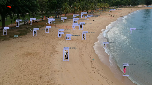
]]>Crowd Estimation at Green Spaces
While Singapore’s Circuit Breaker has lifted, safe distancing may remain a need for the foreseeable future, as we continue to slow the spread of the coronavirus. During this period, authorities will need to continue to ensure safe distancing in public spaces, such as parks, gardens and nature reserves.
Since the initial onset of the pandemic, the National Parks Board (NParks) has enforced safe distancing measures at all its parks, gardens and nature reserves, including Park Connectors, Pulau Ubin and parks managed by town councils. This includes crowd estimation and park patrols at these green spaces. This can be manpower intensive, especially for large public spaces, not to mention laborious when compiling and integrating data into the Safe Distance @ Parks portal.
This is where technology such as drones (UAVs) and Computer Vision (CV) excel. Put together, they provide superior speed, scope, and scalability over manual surveys. NParks has used drones to supplement their efforts in monitoring visitorship levels in major parks, gardens and nature areas, and recognizes that drones with real-time analytics can be an additional tool for crowd counting.

Safe Distance @ Parks is an interactive portal for the public to look for a park near them and check visitorship levels before leaving their house.
Different coloured symbols – an orange square, yellow diamond and green circle – are used to represent the level of visitorship in a specific park.
For example, if an area is experiencing high visitorship, which is indicated by an orange square, the public is advised to refrain from visiting it.
Hackathon at Garuda Robotics
Back in March when we were told to stay home, and half our business postponed overnight, we rallied our people around what we do best: building the future of drone technologies. Except this time, it was a different future, a future that requires drones to play a central role in public health. We split ourselves into 3 teams, and I was part of the team who investigated how we could deploy our AI platform to help NParks estimate crowd levels in parks, gardens and nature reserves.
Our goal was to go beyond the 3 tiers published on Safe Distance @ Parks, and to provide fairly accurate crowd counts in real time from UAVs. Under the Government’s COVID-19 regulations, our company was not regarded as performing an essential service. As such, we drew up a plan where NParks would continue to perform the patrolling, while tapping on our technology to use their drones for crowd estimation. This will complement ground observations and give them a better sense of the density of visitors in a specific area.
The constraints of the system match closely with many similar people counting applications:
- No personally identifiable information should be captured, i.e. there is only enough information to recognize the shape of a human but not enough to know who.
- The goal of the algorithm is to count the number of people over a given flight without double counting as people move around.
- The output of the system that are stored and processed are only people counts, all raw videos are discarded after the count is obtained.
Deep Learning Approach
To work within the constraints, let us take a look at our workflow and algorithm to this challenging problem.
Workflow
- We estimate there to be several drones flying concurrently across various parks, gardens and nature areas at any one time, especially during morning and evening peak hours.
- Each drone is capable of streaming video live to a secure AI platform in the cloud.
- This AI Platform will sanitize the footage and estimate the number of unique persons throughout the park.
- By the end of the flight, the system will report the values to Safe Distance @ Parks administrators to be incorporated into the portal.


Example in-flight footage from step 3
Algorithm
- For object detection, we run our proprietary people detection models previously trained on aerial footage from computer vision research repositories. This generates bounding boxes as above.
- To remove duplicates, we run a well-known deep learning algorithm (DeepSORT) that generates a collection of 128-dimension embeddings for each bounding box that’s matched against embeddings on subsequent video frames.
The pipeline assumes every start / stop of the live stream to be 1 flight and provides people count summary on a flight by flight basis to the appropriate API end points for further summarizing.

Real World Implementation and Operationalization
A good algorithm is not that useful if it only works on a developer or researcher’s computer. By choosing to run the system on our AI platform, NParks or similar customers have the option of deploying this proof of concept on the cloud, on premise, or even on powerful edge devices with GPUs.
Fortunately, we already have the capability to overcome the major hurdles. For example, we can sustain a usable video stream from the drone over mobile networks, whether it’s via our handheld GCS mobile app Plex Pilot, or an on-board computer Garuda CoPilot with dual networks (2 SIM Cards).
Other considerations include the systems integration work necessary between the principal and these autonomous systems and their respective C2 and data analytics platforms.
Next Steps
We successfully emerged from our hackathon and delivered on our very first prototype to a delighted customer. While we won’t know how it would eventually be useful at this juncture, we’re confident that we can take this forward to enhance the product into a more multifaceted product for public health at green areas.

We also trained our model to count cars too, perhaps an LTA project next?
So what do you think? What else can we do in these trying times, to help the country recover sooner from the lockdown? Do share your thoughts with us.
Thank you.
The post Safe Distancing in Parks: Deep Learning Approach to Crowd Estimation appeared first on Garuda Robotics.
]]>The post Extended service level disruption to flatten the curve appeared first on Garuda Robotics.
]]>In line with Singapore’s extension of the Circuit Breaker till 1 June 2020, most of our service levels will remain the same, as detailed in our previous notification (Notice: Temporary Closure of Drone Operations Center and Changes in Service Levels during the escalated COVID-19 situation)
We want to take this opportunity to once again thank our customers who have been patiently waiting for work to be carried out by our team working remotely at their respective homes, battling productivity and connectivity challenge. Your continued confidence in our ability to deliver against all odds, and your fervent belief and alignment with our aspirations, inspires our team to continue to venture into the forefront of unmanned aviation, to make the impossible possible.
This is a difficult period for everyone, especially the aviation industry. Although drones plays a critical role in medical deliveries, delivering food and necessity to the isolated, and maintaining humanity’s basic infrastructure, not all drones can fly during this period of time as we have yet a unified connected urban airspace management infrastructure for unmanned operations.
This is why our Work at the FutureFlight Consortium needs to continue. We have redeployed our manpower and planned a long list of BVLOS tests to be carried out once we regain mobility. As if clockwork, we will be still be receiving our university interns virtually next week to accelerate the Work. We remain confident that the drone industry will emerge stronger in the months to come, especially in coming together to make urban air mobility a reality.
We look forward to seeing you soon in person.
Stay safe and healthy!
Thank you.
Mark and Jiin Joo
Co-founders, Garuda Robotics
The post Extended service level disruption to flatten the curve appeared first on Garuda Robotics.
]]>As drone technology evolves, the quality of camera footage and recording from drones have improved as well. Today we can get high resolution images from just about any commercial drone.
This has pushed all vertical domain owners who invested heavily into drone operations, such as facilities management and security, to further process and utilize their drone aerial footage.
Specifically, most users want the ability to search for their “needle in the haystack” – automatically finding trespassers, identifying illegally parked cars and detecting hairline cracks on buildings and more.
While it is hard to beat a human’s natural ability at object detection and recognition, computer vision wins out in endurance and consistency. Computer vision can help quickly analyze hours of drone footage automatically and generate business insights that gives you an upper hand over your competitors.
Let’s take a look at some of our work in the past year.
- Agriculture
Case Study: Tree Counting
Garuda Robotics originally started embarking on computer vision work to automate and speed up the process of analyzing aerial imagery of palm-oil plantations in Malaysia and Indonesia.
We trained a model that counted trees for palm oil estates that are typically over 2,000 hectares in size. Our latest version has an accuracy rate of over 95%, whilst cutting down data processing time of a 5,000-hectare plantation from days to less than an hour.
Our agriculture business also identifies other crops, helping those farmers build a tree database that’s intricately linked to our in-house plantation AI software, Plantation 4.0. This all-in-one platform helps plantation owners perform inventory checks of their tree assets, demarcate blocks of interest, and identify in near-real-time trees that are sick and require further care.

2. Security and Surveillance: People / Car Counting
People and objects (eg. car) counting in aerial footages are especially challenging to solve as compared to its land-based application counterparts.
First, we need a sizable amount of annotated footage from drone flights. All deep learning neural net algorithms require good manually labelled data to train the model, and some more to test its accuracy.
Training a model on drone footage requires a larger dataset when compared to conventional image recognition pipelines, due to the range of payloads and operating conditions, such as time of day, lighting conditions, and flight altitude. All these factors can greatly influence image profiles. For example, a person looks very different from the front, obliquely from a drone, and when viewed top down.
Case Study: Face Counting

For example, in the use case where we counted faces in a crowd, we augmented the data captured from the sky to replicate eye-level faces as close as possible. This included modifying the detector model that prioritizes on recognizing the top part of the head.
We worked with extremely small faces — as tiny as 10 by 10 pixel boxes — on each frame. We needed to prioritize learning on the general geometry of face outlines, instead of the embedding of multiple facial features (eyes, noses, mouth, ears), before deciding whether each anchor box is statistically significant to be classified as a face.
One side-effect of such optimisation was to yield faster compute rate, processing at up to 40 frames per second. This has a significant impact on our security customers, who will need to put these algorithms to work on large crowds, but utilizing on-the-edge light processes mounted on our drones.
3. Facilities & Infrastructure
In Facilities and infrastructure management, traditional methods of inspections are often time labor-intensive and time consuming. Data collection is harder when the infrastructure is complex and relatively inaccessible by human inspectors.
Case Study: Defects Risk Assessment
We have recently developed an end-to-end inspection solution that captures aerial shots of building facades and performs an automated defects risk assessment (eg. facade cracks, corrosion). Our defects assessment combines a multi-step process to maximize accuracy while not compromising on processing time and privacy.

First, we pass through every aerial inspection footage into a censorship model which removes personally identifiable features on a scene (eg. persons, windows, car plates). To further ensure that our system is guarded against privacy violation, we use only open-sourced datasets for the development of the model.
Subsequent downstream processes classify a dozen defects as specified by government bodies such as BCA, including rust, cracks, peeled paint, cracked glass, and so on. We found that, given the repetitive nature of many of our surfaces, the detectors can get very good for the same fixed set of images (eg. for all HDB flats), but the issue is of overfitting if we needed the model to generalise.
Case Study: Obstacle Detection On-Board
We also need an obstacle avoidance system on-board to avoid being navigated towards a wall while inspecting the building (due to GPS drift, or pilot error).
We have evaluated a number of obstacle avoidance techniques on-board the drone, such as monocular SLAM, LiDAR / IR depth sensors, blob detection, and even trained a monkey pilot at our Drone Operations Center to watch the live video feed and jam the brakes. We have now mostly settled on utilising stereoscopic cameras to build disparity maps as our primary DAA mechanism.
The resulting discrepancy maps shown in the figure below represent objects at different distances to the drone. Both the pilot and the autopilot use this information to identify which of these regions of interest require immediate attention, is in the drone’s line of trajectory, and which failsafe mechanism it has to activate immediately to keep the drone safe.

Privacy Challenge in Computer Vision
Our journey in computer vision isn’t without hurdles, one of which was the PDPA ruling in Singapore, which does not allow us to collect personally identifiable information, even if it’s just for training models, as our models are made commercially available to our customers.
After the model is trained, again PDPA needs to be applied when the algorithm is deployed, as we need to help our customers deliberately mask away all personally identifiable information, before the detection can be done. This is especially true in the inspection world where most of our operations are held in public places such as residential and industrial areas, with identifiable but private features unknowingly being fed into our detectors.
We cannot neglect the importance of privacy when developing any machine learning based solution.
Our Computer Vision Roadmap
There’s no silver bullet to solving deep learning computer vision problems. Each challenge is a tradeoff between slow with high accuracy, and fast with low accuracy. There’s a threshold of minimal acceptable speed or accuracy depending on the use case. For example, search and rescue operations have higher tolerance for false positives in finding survivors, while façade crack detection can live with a few false negatives in the analysis.
We will be launching a data science collaborator programme for selected partners to integrate their deep learning computer vision work into our platform. We will continue to handle the hard part of flying, ensuring the flight is legal, efficient, and repeatable, while our partners can attempt to parse our footage using their respective models.
Do contact us for more details if you or your company works on deep learning computer vision algorithms and would like to solve the drone footage challenge with us.
Summary
Understanding each use case and their needs is important in building the right solution for drone computer vision. We pride ourselves in bringing the latest models and engineering work into our products to address our customer’s needs, and we hope you can utilize our products to meet your business challenges.
The post Deep Learning Computer Vision: Augmenting Drone Operations with AI appeared first on Garuda Robotics.
]]>Drone Operations Center temporarily closed
Our Singapore Drone Operations Center (DOC) will be closed from 5 April to 4 May 2020. All DOC rentals, demonstrations, system testing and integration work will be postponed to a later date.
SaaS and GIS Services available
All online services including Garuda Plex, Plex Pilot, Plex Horizon, and Plantation 4.0 will continue to be available. All Geospatial Analytics services will continue while the team works from home. Our partner drone insurance product CoverFlight will continue to be available.
Flight Operations and Engineering Services available if legal
Flight operations and training services that are deemed legal for select customers in their respective countries will continue (for example, if the customer provides an Essential Service as defined by the Ministry of Trade and Industry, Singapore).
Software Engineering Services will continue to be available. Hardware Engineering Services will be continue to be available, but with delays.
All other services will be suspended. Please get in touch with us if you have concerns on this front.
Our doors remain wide open – contact us online
Garuda Robotics has instituted full Work For Home (WFH) measures. You can reach us on email and other digital channels.
We’d still love to meet you over a video conferencing call!
Virtual DOC
We have begun to virtualise our DOC and will be announcing these online services soon. Unlike typical off-the-shelf services like video conferencing, some of the features will not be available in the virtualised version. We will be sharing more details on this once we’re ready.
Affected services by Industries
1. Plantation Customers
Malaysia’s Movement Control Order (MCO) does not permit drone mapping activities for collecting fresh data. Companies may use this time to upload their previously generated maps to Plantation 4.0 for analysis instead of collecting fresh data.
Reference: Limited oil palm, rubber, logging activities to continue during MCO (The EDGE Markets)
2. Facilities Management Customers
FM work that is deemed an essential service will continue. FM work that requires access to hard-to-reach areas or bring us in contact with many people should be postponed until the Circuit Breaker / MCO measures have been lifted.
3. Security Customers
All drone surveillance and incident response systems, especially those that are or will be flying BVLOS, will continue to be implemented from home.
All Singapore deployments in the pipeline for deployment will be suspended until May. All other system deployments will be on hold until travel restrictions have been lifted.
4. Drone Delivery Customers
All drone delivery services are suspended, as we are limiting Operations Team deployments for health and safety reasons. We will not be able to support any new, near-term requirements for drone deliveries.
However, if you have drone delivery requirements in the medium term (starting 2-3 months from now), please get in touch with us to discuss.
F.A.Q.
Q: Are drone sprayers around the city an effective way to curb COVID-19?
A: There is a rush by governments such as China, Spain, and South Korea, to attempt a variety of methods to prevent the SARS-COV-2 virus from spreading further. This includes loading sprayers with disinfecting chemical to any suspected contaminated surface.
At this moment we have insufficient data to know if it’s effective. If you have such a request, please contact us to discuss.
Reference: 3 ways China is using drones to fight coronavirus (World Economic Forum)
Q: How likely is it for drones to deliver necessities during a lockdown?
Robots such as drones (UAVs) that can be safely operated from an isolated command centre, can be very useful for transportation and logistics during a lockdown.
Drone delivery, especially in urban areas, is still in its infancy. Garuda Robotics has been leading the charge to solve this together with forward looking companies in the FutureFlight Consortium. One such service we have built is an AED Delivery Drone that can fly an AED to a medical volunteer helping to revive a cardiac arrest patient.
The hardest part of the puzzle is to safely integrate these flying robots into the national airspace control system of every city and country where the service operates. Regulators around the world are still racing to put together a coherent framework to enable such services to be available.
May the 4th, be with you
We look forward to your continued support.
Stay healthy and safe as we navigate ourselves out of this crisis.
From all of us at Garuda Robotics
The post Notice: Temporary Closure of Drone Operations Center and Changes in Service Levels during the escalated COVID-19 situation appeared first on Garuda Robotics.
]]>