Where to visit the Hayward fault by bus

16 March 2026

In Deep Oakland I led off the book with a chapter on the Hayward fault, the prime mover that continually makes our landscape. Yes, the Hayward fault is primed to give us a major earthquake. It’s scary to think about. I said, “I know why people prefer not to think about the fault. Every time I visit it, no matter where, I push down the dread. But once I do that, there is room for wonder and interesting things to see.”


Fault creep is damaging Broadway Terrace at the south entrance to Lake Temescal Regional Park

Yes, I visit the fault and you can too. Some places it’s obscure, and others it’s as plain as can be. From Richmond to Fremont, AC Transit bus lines will take you to the fault’s whole length and safely home again. In this post I will present seven maps showing just where the fault runs within Oakland’s city boundaries and what buses will take you to or near it. The bus stops are labeled with the line that serves them — unlabeled stops are served only by school-bus routes.

Map 1 shows the Claremont Resort by the edge of Berkeley, served by the 36 and E lines. Look for curb offsets and related street repairs on Stonewall and Alvarado roads.

Map 2 shows the Montclair business district, served by the 18 line. Fault features include curb offsets and some warped buildings, and the pond in the park was dug in a natural dip in the terrain: a sag basin.

Map 3 shows the LDS temple area at the top of Lincoln Avenue, accessed by the 31 line. See a few curb offsets and surface cracks here, or venture southward for a look at the historic landslide area.

Map 4 shows how the 54 line serves the Jordan swale, a sag basin east of a shutter ridge, and Redwood Heights. The 39th Avenue crossing at the south end has a classic offset curb.

Map 5 shows the Castlemont hill and Oakland Zoo area, served at each end by the 46L line. You can also walk to the north end from stops on the 57 or 98 lines at MacArthur Boulevard and 82nd Avenue, or to the south end from stops on the 57, 90 or 98 at MacArthur and 98th Avenue. There are bent curbs, aligned landforms and the widely offset course of Arroyo Viejo in this area.

Map 6 shows the lower Chabot Park neighborhood south of the zoo, accessible from the Foothill Square bus stops. The residential area holds a clearly visible sag basin, and multiple trails visit the offset hills and stream valleys to the south.

Map 7 shows the same wildland south of Chabot Park plus Sheffield Village, reachable on the 34 and 35 lines. The spur north of Marlow Drive leads into the wilds, while Revere Avenue at the eastern edge displays street and curb cracks.

Collect them all, by bus or by bicycle or scooter. The U.S. Geological Survey has a KML file for the Hayward fault, to load into Google Earth, that made this post feasible. For the most part, the fault locations are approximate, give or take up to tens of meters.

Let’s get to know the fault while it’s still sleeping (and creeping).

Ocher quarry update

2 March 2026

The former campus of Holy Names University, in the hills just above the Warren Freeway, has been for sale for a while, but no one seems to want to move an existing college or start a new one there. The owners of “The Oakland Hills Campus,” BH Properties, just filed plans to put low-density housing there and preserve a few of the old buildings. Left unsettled are the even older presences on the property: the Peraltas’ old chapel and the Ohlones’ ancient ocher quarry.

Right now the property is gated but not posted, so I went there to look at the old places. I first featured the quarry here 15 years ago, when I didn’t know much about it. That was in autumn; the photos today are in just-spring.

The quarry site is uphill 150 meters from the old chapel (more about that later), by a playground behind the former Raskob Learning Institute. I call it a “site” and not a quarry because the evidence points to the boulders being moved here when the campus was built in the 1950s. I think the original quarry site was more spread out and is now covered by buildings. Take a look at the bare terrain, as revealed in the digital elevation model.


From nationalmap.gov; illumination from northwest

Old maps show that the ravine in the middle, where a tributary of Lion Creek runs, used to dominate the scene. Today the stream is culverted and almost everything around the campus has been uprooted or buried, but in 1897, the earliest USGS topographic map shows the chapel site as a low rise above a gentle swale stretching to the southwest. The freeway excavation obscures what was originally a saddle between the headwaters of Peralta and Lion Creeks.

Local historian Dennis Evanosky says that Antonio María Peralta, the Mexican rancher who first possessed this part of Oakland, called the place “Loma Colorada,” suggesting that this “red hill” is where the Ohlones produced ocher from boulders exposed here. And the good stuff is really red.

Dennis says Peralta held on to this parcel longer than his other lands. The chapel he built here was a noted landmark, with an inspiring view. And like Indian Gulch, this place must have been unusually significant to Peralta’s unpaid Ohlone workers. They remembered the traditional uses of ocher in body paint, sunscreen, dyes, medicine and burials. This ocher patch had been their regional monopoly, supporting rich trade connections throughout the Bay area.

Some of the boulders have hollows in them where the quarriers pounded and harvested raw material.

I suspect that the boulders have been turned, though there’s no easy way to be sure. The typical mortar holes we picture, used to turn acorn into meal, needed the hardest rock, and they needed to face upward, like the example below from Berkeley’s Mortar Rock Park. Grinding soft red rock into grit to collect in baskets is a whole different operation, it seems to me, and the hollows face different directions.

The boulders aren’t consistent in their composition, nor are they consistent with the bedrock exposed just downhill. They’re spaced artfully and don’t form any sort of pattern, the way they might if they were exhumed by erosion as an ensemble. In short, I interpret the quarry site as a modern artifact.

Still, the boulders are pure and distinctive, unlike any other place in Oakland, and they’re at the far north end of the Leona volcanics that give rise to our ocher occurrences. (See my backgrounder on how ocher forms.) I surmise that the boulders emerged at this spot because the bedrock was fertile, the topography retarded erosion and the ocher evolved gently to a better state of purity, then weather out in large bodies ready to use.

The Ohlones harvested ocher here for thousands of years, a kilo at a time. Suddenly the Spanish arrived and took them all to the San Jose Mission, the king gave the Peraltas the land, and when the missions failed the surviving Natives became the Mexican ranchers’ serf class. Antonio Peralta set up a chapel here for Catholic priests, who visited regularly. Eventually the land came into American hands, and in 1908 an architect born in Ontario named George Edward McCrea (1871-1943) bought it and built a house here for his family, adding rooms over the years. A nearby plaque says the house incorporated the chapel’s foundation.

In 1943 McCrea’s surviving son Robin gave the “ancient Indian camp” to the city of Oakland for use as a park. It appears on a 1950s road map as McCrea Park, but the city did little to improve it. A few years later the College of the Holy Names sold their original location on Lake Merritt to the Kaiser conglomerate and sought this land for their next campus. The city sacrificed the park for the college, inducing Robin McCrea to deed the land to the college and substitute a parcel on Lion Creek in its place, which is today’s McCrea Park. (It’s conceivable that some red boulders were brought up from there.)

The college burgeoned and thrived (until 2023), but in all of its bulldozing and landfilling did little to preserve the historic assets. The McCrea house, once a charming farm cottage, is in poor shape today, between decrepit and tumbledown, and the Ohlones’ camp is wiped out except for the cluster of boulders. BH Properties would turn it all to an ungainly meld of public cultural center and suburban sprawl, with no room left for the aboriginals.

The tribes haven’t forgotten this place, as I learned years ago. The Ohlones were recently granted a 4-acre reserve in nearby Joaquin Miller Park. They gave it a name in the local Chochenyo language, Rinihmu Pulte’irekne, “Above the Red Ocher.”

Charles Burckhalter, Oakland science hero

16 February 2026

The name of Charles Burckhalter might ring a bell for Oaklanders: Burckhalter Elementary School, in East Oakland on Burckhalter Avenue, is named for him. I visit nearby Burckhalter Park, whenever I’m walking in the area, for its water fountain and its view of the former Leona Quarry.


Burckhalter Park, 2018

Astronomers remember him, and asteroid 3447 Burckhalter is named for him. He’s an important figure in our city’s history who has a little-noted geological connection.

Charles L. Burckhalter (1849-1923) was a farm kid from Ohio who came to work at his brother’s general store in Truckee in the late 1860s. There he spent evenings with a local attorney who stargazed with a five-inch* telescope — imagine how the night skies looked up there back then — and found a passion for astronomy.

After his marriage to Mary Catherine Nash in 1878, he moved to Oakland and took a job at a San Francisco insurance company. He built a 4½-inch telescope, mounted it in his Chester Street back yard on a stout brick foundation under a steerable canvas dome, and had himself a genuine observatory. By 1883 he’d upgraded to a 10½-incher, a very large instrument for an amateur, and made observations worthy of publication in the scientific journals.

At this point the city hired Burckhalter to teach geography and astronomy at the high school, at 12th and Market Streets, and help out at the new public observatory that Anthony Chabot had built in Lafayette Square for the citizens of Oakland in 1883. His star had really begun to rise.


Plaque at Lafayette Square on 11th Street

He was named Director of the Chabot Observatory in 1887 and served for thirty-five years, the rest of his life. He started the tradition of giving lectures on cloudy nights, using lantern slides to show audiences the wonders of the sky. He never got a college degree, but the papers often called the beloved teacher “Professor Burckhalter.”

Burckhalter’s interests went beyond the sky to the air and the Earth. His weather observations were a monthly feature in the newspapers, and he took note of earthquakes too (see an example from 4 January 1906). He installed a seismograph at Chabot Observatory in the 1880s, at the time a newfangled contraption. Astronomers were some of the earliest users of seismographs because large telescopes are precision instruments that notice even tiny disturbances. Lick Observatory, newly built in the mountains east of San Jose, had one too. Later that year, in the wake of the San Francisco earthquake, he took part in forming the Seismological Society of America and served on its founding board of directors.

1906 was a special year for Burkhalter that began routinely. He announced a lunar eclipse for the night of February 8-9. That night, the Tribune reported, he turned off the doorbell and “trained his telescope on the surface of the diminishing disk to discover, if possible, [whether] frost forms around the lunar volcano Linne.” On the last night of March he was in Berkeley at the annual meeting of the Astronomical Society of the Pacific, an organization formed by his enthusiastic inspiration.

Eighteen days later, the San Francisco earthquake came as dawn began. Burckhalter counted 19 aftershocks over the next 13 hours. Over the next few days, the papers reported him assuring the public that there would be no “tidal wave” coming and that because earthquakes cannot be predicted (still true today), “the rumors that several more are en route should not be accepted.” Within the week, he was enlisted in the California Earthquake Investigation Commission, headed by UC Berkeley professor Andrew Lawson, along with several other prominent astronomers.

Astronomers were key people for two reasons. Their seismographs were one, but the other was that they were habitual, precise observers of time who were always awake at night and had clocks that were accurate to the second. Burckhalter and Armin Leuschner were assigned to collect as many reports as they could of the time the earthquake started, whether it was human observations or stopped clocks. When commission member Harry Reid set out to use these arrival times to determine the epicenter, only a handful of observations passed muster, but they yielded an epicenter at Olema in Marin County. It was good work considering the crude data. Today we put the epicenter a couple miles off Ocean Beach, about 30 kilometers south.

Unfortunately, Chabot Observatory didn’t yield suitable data. Its two clocks stopped at different times, and its seismograph recorded a useless scribble — but so did everyone else’s. Its instrument was a Ewing duplex pendulum seismograph that suspended a stylus over a disk of smoked glass, useful for small, simple events but overwhelmed by the 1906 quake, which shook strongly for about a full minute.


From the Lawson report, volume 3 atlas, Rumsey collection

The earthquake closed the Chabot Observatory for four months, but there was little damage and the telescopes were unharmed. Burckhalter resumed his weather reports, after skipping April, and went on in his distinguished career. As light pollution increased in downtown Oakland, he raised the money and political support to move the observatory to Leona Heights in 1915, where it remained for the next eighty-plus years. The observatory’s mission has followed Burckhalter’s educational program faithfully through directors like the memorable Kingsley Wightman and today’s leaders at the Chabot Space & Science Center.

More reading

OakWiki entry

A 1961 Tribune biography

Obituary by the Astronomical Society of the Pacific

* The inch size of a telescope refers to the diameter of its light-gathering mirror or lens.

The story of blue rock

2 February 2026

There was a long period in Oakland’s history when the city cared deeply about its streets and took great pains with the rock it used in them.

The tiny village that became Oakland in 1852 was founded in a large grove of live oaks growing on a platform of fine sand, deposited by the wind during the latest ice age. This wasn’t a problem for a tiny village, but once commerce began the sandy ground underfoot turned — well, turned to sand, mucky in winter and dusty in summer. Within a decade the city set out to pave its streets.

At the time, this meant using the macadam method, named for Scottish engineer John McAdam. A shallow roadbed was filled with thin layers of crushed rock, each layer using finer material, topped with a layer of sand and rock dust. Each layer was watered and pressed down with heavy iron rollers. Macadam roads worked well with horses and wagons, and they served the town as it grew for the next fifty years.

The nearest source of crushed rock was in the hills three miles from the waterfront in the direction of Broadway. A man named Horace Whitmore started a quarry there, on Broadway where it meets 51st Street and Pleasant Valley Boulevard. Today the former quarry holds the Ridge shopping center, where a historical exhibit commemorates it as the Bilger Quarry. It had several names during its working life.

In 1864 the city specified rock from the Whitmore quarry in its first road-building contracts. By geological happenstance, it was excellent stone: tough, fine-grained lava rock, known in the trade (and to geologists) as trap rock, dark gray with a slight bluish tinge.

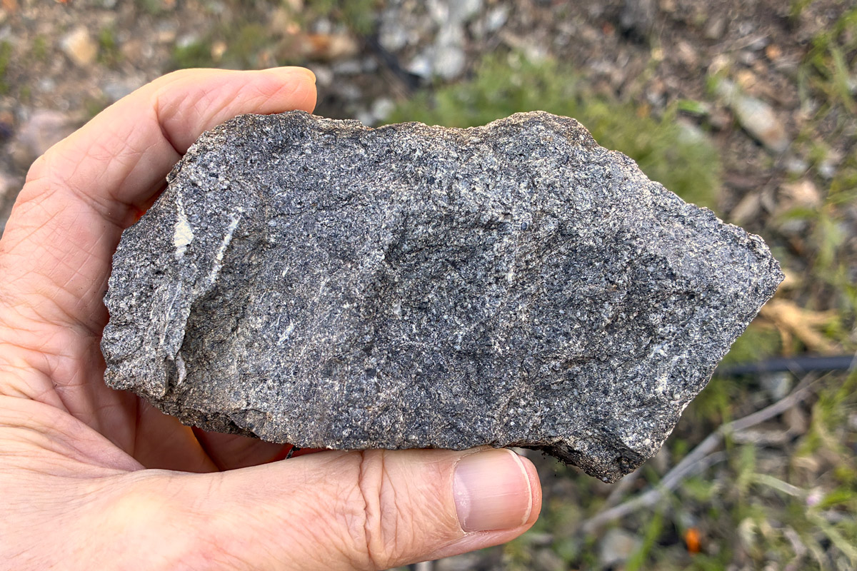
There was lots of decent stone in the hills, where Piedmont sits today, and other quarries began to produce it, but Whitmore’s blue rock was the clear favorite. The geologic map shows that while the other quarries produced good sandstone and argillite, Whitmore’s pit tapped an intrusion of real lava, classified as quartz diorite.


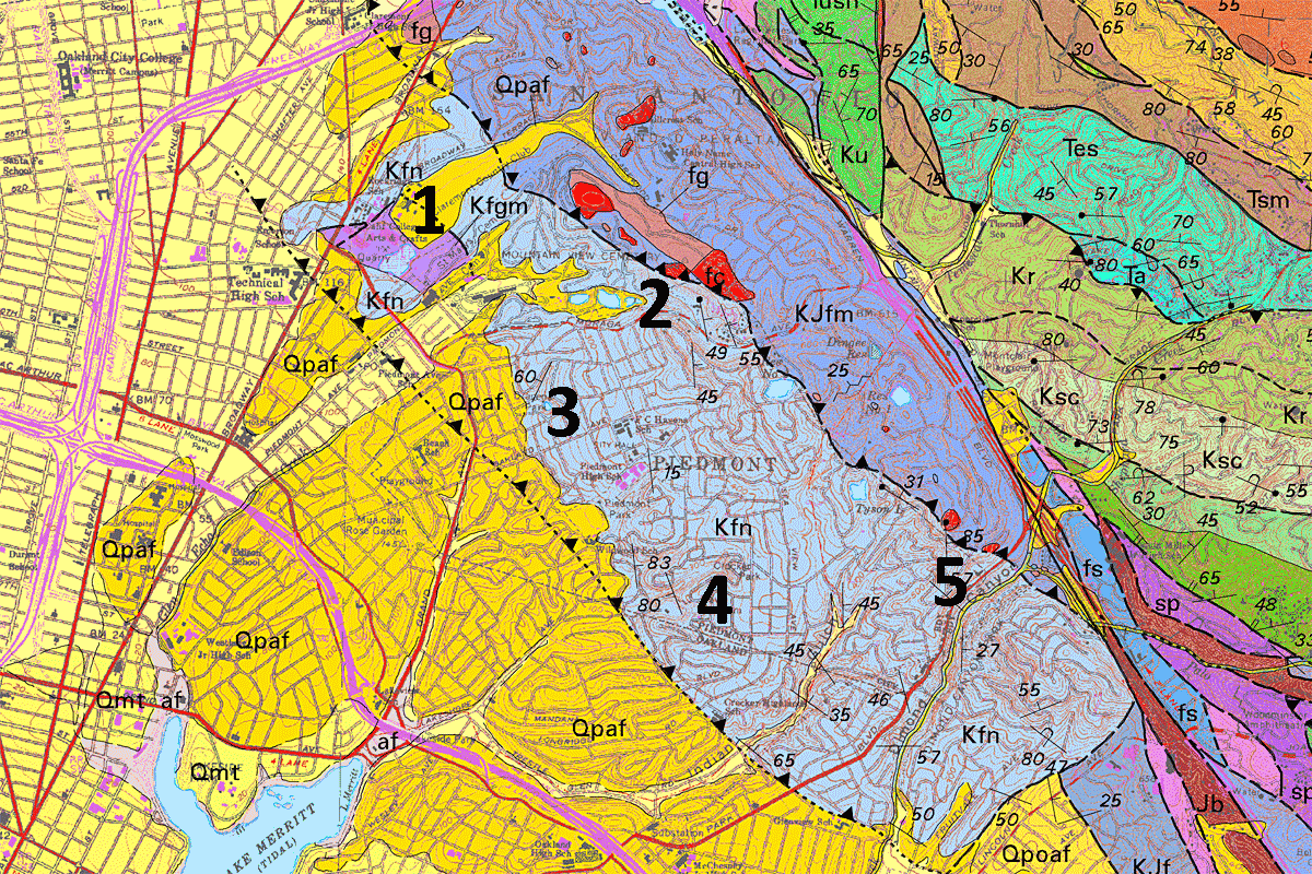
Major quarries in the Piedmont bedrock block: 1, Whitmore/Bilger; 2, Blair Quarries; 3, Blair’s Quarry; 4, Alameda Macadamizing Co. Quarry; 5, Dimond Canyon Quarry.

Whitmore died in 1870, and a new firm, the Oakland Paving Company, bought the quarry.

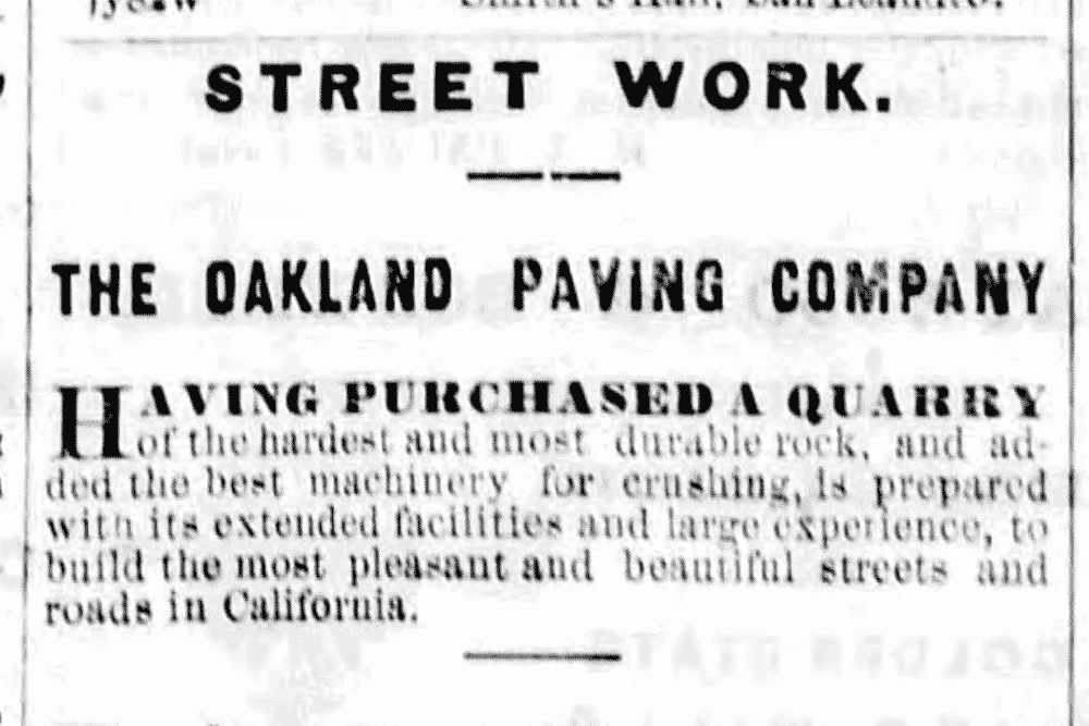
In 1871 mayor Nathan Spaulding singled out their product in an address to the City Council: “The macadam is composed of blue trap rock, which is exceedingly hard, tough and durable, and under a proper and judicious system of repairs, it is believed that our macadamized streets will last for a great number of years.” Naturally Broadway was macadamized first, all the way up to the quarry.

City road-building contracts required “hard gray or blue trap rock,” but they used a practical rather than a geological definition. If the rock was dark, hard, homogeneous and dust-free, it would do for macadamizing city streets. It wouldn’t crumble under prolonged use, and if sprinkled with water regularly it wouldn’t raise a lot of dust.

Although all of the Piedmont quarries prospered during the macadam era, Oakland Paving was zealous about its hard blue trap rock. Even in San Francisco, supervisors in 1873 favored “Oakland blue trap rock.” The Daily Transcript said, “It combines the indispensible requisites for making good and durable roads. It is hard, almost to impregnability. And yet when pulverized it throws off little dust, and when watered daily soon becomes packed down into a surface smooth and of adamantine solidity.” (21 November 1873) The Tribune wrote, “It gives us smooth streets, well packed, and pleasing to the eye. Vehicles pass noiselessly over it; and it proves to be durable, and therefore is an economical material to use.” (14 December 1876)

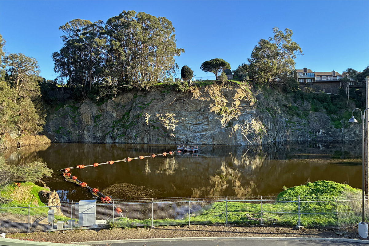
Oakland Paving produced its rock from the east side of the property, next to the cemetery, where a deep pond remains today. The high wall of true blue rock rises on the far side, looking as strong as ever.

“Blue rock” became a generic term in the central Bay area, which made some sense because stone much like it occurs in several different places. In fact, Oakland Paving acquired a similar quarry across the Bay at McNears Point, which under its current operators provides much of the riprap along the Bay shore. (It’s blue rock, but not the blue rock.)

By the late 1880s, the macadam was getting old and expensive to maintain. Bitumenizing was the newest best thing, using natural asphalt rock mined in the Santa Cruz Mountains, and modern asphalt paving, made possible by abundant petroleum, soon followed. Nevertheless Oakland was proud of its rock, and in 1892 the city specified that “1st class rock shall be rock of igneous character and formation, trap or basalt, of irregular cleavage, and such as shall not lose by erosion and fracture upon testing same in the ‘rattler’ belonging to [the] city of Oakland for purposes of testing rock, revolving at the rate of not less than 28 revolutions per minute for three hours, more than fifteen per cent of its original weight.”

Around 1890, when the three founders of the Oakland Paving Company died, Frank Bilger and Anson Blake (son of founder Charles T. Blake) took over and adopted a high profile. They were energetic, well-connected entrepreneurs at a time when Oakland was still a chummy business town. The days of macadam were passing, although oil-bound macadam replaced water-bound macadam for a few years. (The memory survives in the word “tarmac” sometimes used for airport runways.) The firm devised a version they called rockite, but it evidently found few buyers. Their quarry began to lose its place at the top of the pile. A new quarry in Leona Heights was found to yield “a fine quality of blue rock,” and in a test of five quarries the rattler proved the Leona Heights Quarry to have the best rock in town. This evidently was a blow to Blake and Bilger, because after that they emphasized their original blue rock as much as they could.

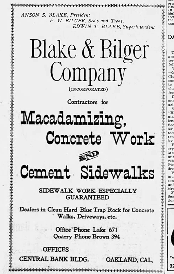
In addition to the bulk crushed-rock business, Blake and Bilger spun off a concrete contracting company, Blake & Bilger, which laid sidewalks in Oakland and neighboring cities, while Oakland Paving handled larger developments involving integrated curbs, asphalt roadbeds and sidewalks. Both firms used fine crushed rock — aggregate — from the Broadway quarry, and their sidewalk stamps survive. Later still they reincarnated the base business as a diversified building material company.

In 1905 the Blake & Bilger Company announced its presence in the papers as “dealers in clean hard blue trap rock for concrete walks, driveways etc.” They clung to the word “blue” that had defined the firm from the beginning.

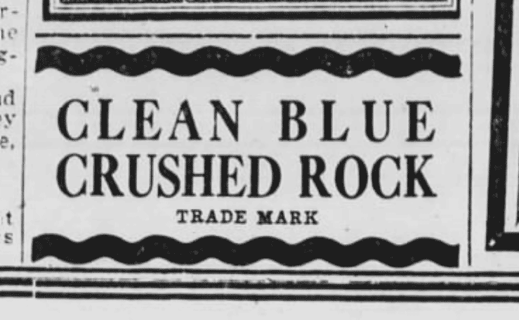
By 1914 they had refined an ad campaign around “Clean Blue Crushed Rock,” touted as the “very best rock for concrete and street work.” At some point the original pit was abandoned and allowed to fill with groundwater. By that time no one talked about macadam any more. This photo, probably from the 1920s, shows the quarry eating into the hillside nearer to Broadway. Neighbors had moved into the area, and in response to their complaints the quarry switched to electric equipment and announced a new, quieter detonation method.


Photo courtesy Bob Demello

The rock from this sector was no longer the hard quartz diorite, but a lighter-colored altered material more like what the old Piedmont rivals had sold. Nevertheless Blake and Bilger touted their Clean Blue Crushed Rock in ads that said less and less, in 1924 arriving at the absolute minimum.

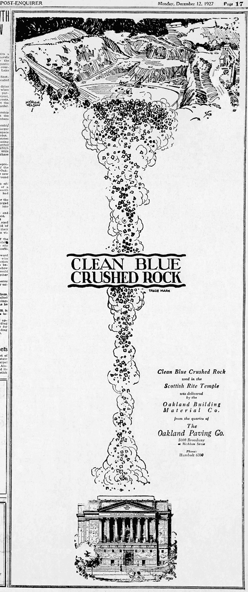
There were also occasional half- and full-page spreads boasting of the major buildings that had used the very best rock for concrete: the Campanile and the Greek Theater. The Medical Arts Building at 19th and Franklin, and the Leamington Hotel across the street. City Hall and the great Civic Auditorium. The climax came with the Scottish Rite Temple, in 1927.

But the last time “Clean Blue Crushed Rock” appeared in the papers was a few months later in coverage of a luxury demonstration home in Piedmont Pines. The term “blue rock” itself was forgotten by the forties, a long time ago.